
 MANILA, Philippines - A month before President Aquino’s planned state visit to Beijing, the Philippines government has formally protested before the United Nations over China's blanket claim of the entire South China Sea.
They said it overlapped with the Philippines' claim of Kalayaan (Freedom) island chain that was closer to the Philippines than China, an investigative news agency said.
 The Philippines said Thursday it had lodged a formal protest at the United Nations over China's claims to the Spratly islands and adjacent South China Sea waters.
- The newest controversy in the decades-old multilateral dispute centres on formal notes sent by China to the UN secretary general in 2009 outlining the basis of its claim, foreign ministry spokesman Ed Malaya said.
- "Yes, we can confirm that the Philippines filed a note with the UN expressing its position on the nine-dotted line," he told AFP, referring to a map attached to the Chinese letter that delineated China's claim.
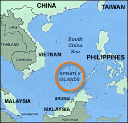
- The Philippines and China, along with Brunei, Malaysia, Taiwan and Vietnam, claim all or part of the Spratlys, which are believed to sit on vast mineral resources.
 Manila last month complained that Chinese patrol boats inappropriately harassed a Philippine oil exploration vessel in disputed waters near the Spratlys.
- The Philippines later announced plans to pursue oil exploration in the South China Sea and to upgrade a military airfield on Thitu island.Thitu is the largest of the seven Spratly islands that the Philippines occupies.
 The Philippines claims more than 50 islands in the archipelago.China has recently reiterated its exclusive claims to all the disputed areas and their adjacent waters, much of which is closer to Philippine land than Chinese.
- The map is called “9-dash line” or “9-dotted line” because it shows a series of nine dashes or dotted lines forming a ring around the South China Sea area, which China claims is part of its territory. The area includes the Spratlys group, a cluster of oil-rich islands disputed by five other countries, including the Philippines.


 Firstly, the government said, the KIG constitutes an integral part of the Philippines and to which is has sovereignty and jurisdiction.
- Secondly, the Philippines exercises sovereignty and jurisdiction over the waters around or adjacent to each relevant geological feature in the KIG under the international law principle “the land dominates the sea," as provided for under the UN Convention on the Law of the Sea (UNCLOS).
- Finally, the government said, China’s claim on “relevant waters, seabed and subsoil" related to the KIG has no basis under UNCLOS as that jurisdiction belongs to the Philippines.

 China has been using the map with nine dashes in asserting its territorial claim over the whole of the South Sea. But the map first made its way to the UN body, when China used it to challenge the claim made by Vietnam and Malaysia over their extended continental shelves in the South China Sea.


Post a Comment